

 My grandfather Dick O'Keefe told the story that when he was a young man he was travelling a country road in horse and buggy. At a fork in the road he did not know which to take. He saw (in his words) a Chinaman walking along carrying baskets balanced on his shoulders with a pole.
"Which way to Donnybrook Station, Charlie?" Asked Dick.
"Why you say my name "Charlie"? asked the Chinaman.
My grandfather Dick O'Keefe told the story that when he was a young man he was travelling a country road in horse and buggy. At a fork in the road he did not know which to take. He saw (in his words) a Chinaman walking along carrying baskets balanced on his shoulders with a pole.
"Which way to Donnybrook Station, Charlie?" Asked Dick.
"Why you say my name "Charlie"? asked the Chinaman.
 "Oh, I just bloodywell guessed it!" said my grandfather.
"Well, you just bloodywell guess your way to Donnybrook Station!" replied the oriental.
"Oh, I just bloodywell guessed it!" said my grandfather.
"Well, you just bloodywell guess your way to Donnybrook Station!" replied the oriental.
21.  |
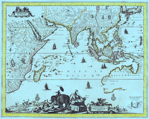
Zhu Di's Map of the World Family(this story is disputed and may not be completely true.) In 1405, Zhu Di sent his favorite Admiral, Zheng He, on a mission to unite the peoples of the "Four Seas"— that is, the World Family. Midway throughthis enormous undertaking of many overseas voyages, a Ming artistprepared this elegant but somewhat stylized version of the world. It was based on information contained in a variety of field maps and navigational charts. The composite map was intended to represent the final unification of the World Family under the leadership of the Ming Dynasty. It was a visual testimonial about foreign nations (or barbarians) that paid homage to the Son of Heaven in Beijing. It was also a memorial to the role of world commerce in preserving the peace between nations; and it was a graphic representation of the system of transoceanic routes that formed Zheng He's colossal maritime trade network. Zhu Di's dream of a United Family did not last for very long. Within a few years, Portuguese spies obtained copies of thismap. And they used it as the principal tool in world conquest. During that conquest, Europeans claimed they were superior because they had better weapons and maps. They boasted that "the Victor writes the history." And so, the legacy of Zheng He and the heritage of other ancient voyagers faded into the twilight of Western doctrine. This is a revolutionary map. It will finally force Western scholars to abandon the doctrine of Eurocentrism that has dominated world history for the past 500 years. In the 21st century, the Global Community needs a factual history that reflects the true events of the past. This map can precipitate a paradigm shiftin history. Such a paradigm shift is essential in order to dislodge the medieval cultural anchors that are holding us back. Then we can truly build a philosophical foundation of equality for the Whole World Family. |
 Macassan prau's, or fishing boats, fished the waters of northern Australia from the Kimberley region, eastward to the bottom of the Gulf of Carpentaria. Possibly establishing seasonal camps and processing factories on the southern coastline of the Gulf or the Wellesley Islands. The Macassans may even have fished as far east as the Torres Strait and the Great Barrier Reef, though these last two regions are generally dismissed by historians such as MacKnight and Stokes. The Macassans fished for trepang, curing it in temporary camps on the northern Australian coastline until the turn of last century when colonial restrictions had eventually made it unprofitable for the prau owners.
Other Muslims visited the northern coastline, including the Chinese Muslim Admiral Cheng Ho in 1405-1433 in a fleet of 400' long ships. Arab Muslim explorers produced the first maps of Australia. The Muhammad Ibn Musa al-Khwarizmi map of the Sea of Java of 820 CE shows the northern coastline from Eighty-Mile Beach in Western Australia to Cape Melville and Princess Charlotte Bay in North Queensland. The Al-Istakhari Map of 943 CE, details the Australian coast from the Kimberley's to the Townsville area.
The seasonal Macassan prau's would have included Haji's, who must have conveyed information about Marege', to Muslims from the Bosnia, Athens, Istanbul, North Africa, India and the Middle East. While these Muslims were significant in early pre-European history, they left few reminders, possibly supplying awareness and some detail about Marege [Australia] via the Malay Archipelago or through Muslim maps to early European explorers.
Macassan prau's, or fishing boats, fished the waters of northern Australia from the Kimberley region, eastward to the bottom of the Gulf of Carpentaria. Possibly establishing seasonal camps and processing factories on the southern coastline of the Gulf or the Wellesley Islands. The Macassans may even have fished as far east as the Torres Strait and the Great Barrier Reef, though these last two regions are generally dismissed by historians such as MacKnight and Stokes. The Macassans fished for trepang, curing it in temporary camps on the northern Australian coastline until the turn of last century when colonial restrictions had eventually made it unprofitable for the prau owners.
Other Muslims visited the northern coastline, including the Chinese Muslim Admiral Cheng Ho in 1405-1433 in a fleet of 400' long ships. Arab Muslim explorers produced the first maps of Australia. The Muhammad Ibn Musa al-Khwarizmi map of the Sea of Java of 820 CE shows the northern coastline from Eighty-Mile Beach in Western Australia to Cape Melville and Princess Charlotte Bay in North Queensland. The Al-Istakhari Map of 943 CE, details the Australian coast from the Kimberley's to the Townsville area.
The seasonal Macassan prau's would have included Haji's, who must have conveyed information about Marege', to Muslims from the Bosnia, Athens, Istanbul, North Africa, India and the Middle East. While these Muslims were significant in early pre-European history, they left few reminders, possibly supplying awareness and some detail about Marege [Australia] via the Malay Archipelago or through Muslim maps to early European explorers.


+copy.jpg)


.jpg)


 G
G


.jpg)


No comments:
Post a Comment