 God of War.
*****************************************************************************

Afgha-Pak border at Khyber Pass
Location (address): Afghanistan, Road connecting Jalalabad and Peshawar through Kotal
Longitude: 71° 5' 20" Latitude: 34° 7' 36" The Khyber Pass is a 53-kilometer (33-miles) passage through the Hindu Kush mountain range. It connects the northern frontier of Pakistan with Afghanistan. At its narrowest point, the pass is only 3 meters wide. On the north side of the Khyber Pass rise the towering, snow-covered mountains of the Hindu Kush. [afghan-network.net]Pakistan launches Khyber Pass offensive to support US-led forces
Helicopter gunships strike along border in effort to secure supply lines for western troops, officials say
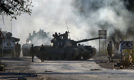
Pakistan army tanks arrive at Jamrud, a town in the Khyber tribal area Photograph: Ameer Zada/AP
Pakistani helicopter gunships today launched attacks along the Khyber Pass as part of a new offensive to secure vital supply lines for western troops fighting Taliban insurgents in Afghanistan.
Authorities suspended the shipment of supplies to the Afghan border yesterday in preparation for the campaign to clear out insurgents who have destroyed hundreds of supply trucks in recent months.
"Two helicopter gunships pounded militant hideouts while troops moved with tanks to secure the area," said Jehangir Khan Afridi, an administration official in the Khyber region.
The US military praised the campaign and said the temporary closure of the road was not a problem.
Over 65,000 western troops in landlocked Afghanistan rely on the winding, mountainous road for delivery of up to 75% of their fuel, food and other goods, which arrive via the port city of Karachi in Pakistan.



+copy.jpg)







.jpg)


 G
G


.jpg)


No comments:
Post a Comment